
Exploring Colorado’s Front Range Plane Wrecks
Many plane wrecks in Colorado’s mountains remain frozen in time, a testament to the forces of nature and the fallibility of human error. Remnants of hundreds of air accidents are scattered in the Front Range, though in many cases the evidence is scant: a small gear, a few pieces of metal, or a smattering of rusted screws. However, a few extensive debris fields are up there too, some of which have been bleaching in the high-altitude sun for more than 50 years.
Visiting these sites evoke a range of emotions. For most wreck chasers, the allure isn’t in the macabre but rather curiosity. The mechanical aftermath and the sequence of events that added up to disaster all tell stories whose physical imprint remains too remote or too difficult to purge from the land.
Some wreck sites are surprisingly close and easy to access, while others require a good degree of fitness and navigational skills. Explorers looking to see these wreck sites firsthand can start with these three spots. It is important to never tamper with or remove any debris, no matter how small, from wreckage sites—in many cases, it’s illegal. On a larger scale, aviation archaeology involves examining crash sites and, these destinations offer significant debris fields and historical notoriety.
1. Wichita State Plane Wreck

James Dziezynski
Location: Shoulder of Mount Trelease near Loveland Ski Area
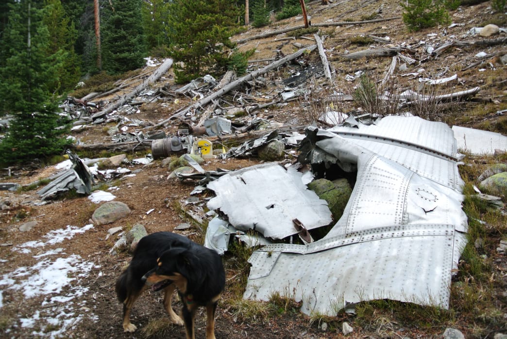
This is the most accessible and most dramatic of Colorado’s plane wrecks. Shattered remains of the Martin 4-0-4 have rested in the forest since October 2, 1970, when the pilot of the craft swept down into the box canyon along I-70 for a better view for the Wichita State football team on board. When the pilot descended too far, he was unable to pull high enough above the trees and crashed. Of the 37 passengers on board, only six survived. The debris field is quite large, with many recognizable objects strewn throughout the wreckage of the aircraft.

James Dziezynski
It should be noted that there are memorials at the wreck site as well as a modest monument directly off I-70 about a mile from the crash side (you can see it on the westbound side near a large digital highway sign). Incredibly, this site is less than a mile as the crow flies from I-70, but remains lightly visited. Please be respectful when you visit—unlike other wreck sites, there is a significant essence of the human spirit remaining in this quiet, unassuming destination.

James Dziezynski
How to Get There
From I-70, take the the Loveland Exit (216). Coming from westbound I-70, take the exit, then take a sharp right turn onto a dirt road before crossing under I-70 and follow it a few hundred feet to parking at a gate. If exiting eastbound, take a left off the exit, then left under the I-70 bridges and then right to the same dirt road. This accesses Dry Gulch. Follow the road up roughly a half-mile and before a fenced storage lot, take a left up an old, overgrown access road into the woods. There are no marked trails here, but the initial path/road is steep but well defined. About a mile in, look for a cairn on the left of the trail. This social trail leads to the wreck, but may be tricky to spot. The coordinates of the wreck are 39°41'35.69"N 105°52'56.94"W. (Note if you put those coordinates in Google Earth, you can make out a bit of the wreckage.) Mountainousword.com also offers a more detailed guide.

James Dziezynski
2. Navajo Peak

James Dziezynski
Location: 12,900 feet near the summit ridge of 13,409-foot Navajo Peak
It takes some effort to reach this wreck site, as it involves off-trail hiking and scrambling up a somewhat hard-to-find, loose, rocky gully. Debris from the C-47 craft is strewn to the base of the gully, where small gears and sheared metal is a prelude to the larger wreckage. Scramble up the eponymous Airplane Gully 900 vertical feet to 12,900 feet, where the fuselage, motors, wired boxes, and other debris sit. The wreckage has remained here for almost 60 years—the plane crashed on January 21, 1948 due to strong winds and foul weather. Most hikers will continue on to the class 3 summit of Navajo Peak after coming this far, though it’s an optional scramble with some thrilling exposure.

James Dziezynski
How to Get There
Start from the Long Lake Trailhead at Brainard Lake Recreation Area. Follow the Long Lake Trail to the Isabelle Glacier Trail, and at 3.5 miles from the start, head off trail and begin the tricky navigation through marshy, rocky terrain to the base of Airplane Gully. Ascend the gully, staying right at a high fork that leads to the bulkhead and main wreck site. Read more about this route on summitpost.

James Dziezynski
3. Jasper Peak Wreck

James Dziezynski
Location: Unnamed lake at 11,575 feet, near Jasper Peak
Unlike the previous two wrecks, this crumpled plane is a small craft. According to crash records, the plane is an AT-6 that went down on December 15, 1971. This is confirmed by the “checked wing” on the side of the craft. Developed in 1935 as an “Advanced Trainer” (thus the AT in the name) for Mustang fighters in World War II, the AT-6 remained in production until 1962, by then relegated to airshow duty. It’s quite a curious aircraft to be in the mountains, and the cause of the crash is unknown. The wreck itself is mashed into a boulder but is very recognizable. The hike up goes off-trail a bit to an unnamed lake at 11,575 feet at the foot of Jasper Peak (itself not formally named but well known in Colorado by that moniker).

James Dziezynski
How to Get There
Start at the 4th of July Trailhead out of the tiny town of Eldora. This road is rocky and bumpy but carefully driven passenger cars can make it to within 200 feet of the trailhead proper and there is parking at this junction. Hike on the Arapaho Pass Trail 1 mile then divert to the Diamond Lake Trail. At 0.4 miles farther at Middle Boulder Creek, go off-trail and navigate through up through a tricky basin to the unnamed lake. The lake is located at 40.000076, -105.671124 (Google Map coordinates) and is much easier to reach in summer, when the snowfields on the approach are mostly gone. At roughly 2.7 miles from the start of the trek, you’ll reach the unnamed lake; on its west side, the wreckage gleams in the sun.

James Dziezynski
If You Go
For more information on many of the plane wrecks in Colorado, visit planecrashmap.com—and be prepared to be shocked how many planes have crashed in Colorado. Another older but still interesting website is coloradowreckchasing.com. It features good info from a passionate wreck chaser, but keep in mind that as of 2016, the site hasn’t been updated in over a year.
Written by James Dziezynski for RootsRated and legally licensed through the Matcha publisher network. Please direct all licensing questions to [email protected].
Featured image provided by James Dziezynski
Asa Firestone was born with an entrepreneurial spirit and has cultivated hospitality expertise in the picturesque landscapes of Lyons and Boulder, Colorado. As the co-owner of the A Lodge, his journey epitomizes dedication, innovation, and a deep-rooted commitment to community.
Asa’s journey began with a profound appreciation for travel and exploration. His early experiences staying in lodges around the world ignited a passion for creating memorable experiences for others. Armed with this passion and a keen business acumen, he embarked on a mission to redefine hospitality in his own backyard.
In 2008, Asa’s vision came to fruition with the establishment of the A Lodge in Boulder, Colorado. Nestled amidst the majestic Rocky Mountains, this Boulder hotel quickly garnered acclaim for its blend of rustic charm and modern comfort. Under Asa’s guidance, the A Lodge became more than just a place to stay; it became a destination where guests could immerse themselves in the unparalleled beauty of Colorado while experiencing genuine hospitality.
However, Asa’s ambitions didn’t stop there. Recognizing the growing demand for unique accommodations in Boulder, he expanded his footprint by acquiring and revitalizing a second property in the heart of Lyons. This expansion not only solidified Asa’s reputation as a visionary entrepreneur but also furthered his mission of providing exceptional hospitality experiences to a broader audience.
Beyond his role as a hospitality magnate, Asa Firestone is deeply invested in the communities he serves. Whether through supporting local initiatives, fostering sustainable practices, or championing the arts, he remains dedicated to making a positive impact at both the local and global levels.
Asa’s leadership exemplifies a harmonious blend of passion, innovation, and compassion. His unwavering commitment to excellence continues to set the standard for hospitality in Lyons, Boulder, and beyond. As guests continue to flock to the A Lodge, they are not only welcomed into a warm and inviting space but also into the visionary world of Asa Firestone.